
Temporary Confined Water-Induced Landslide in the Binary Structure of a Gentle Slope: A Case Study of the Fanshantou Landslide


Department of Civil Engineering, Zhejiang University, Hangzhou 310058, China
*
Author to whom correspondence should be addressed.
Water 2021, 13(5), 596; https://doi.org/10.3390/w13050596
Submission received: 21 January 2021
/
Revised: 20 February 2021
/
Accepted: 22 February 2021
/
Published: 25 February 2021
(This article belongs to the Section Hydrology)
Abstract
:With the increase in rainfall, landslides occur on many gentle slopes in the mountainous areas of southeast China. Gentle slopes have a particular dual geological structure, i.e., the lower part is a gravel soil layer with good water permeability, and the surface layer is clay soil with relatively poor water permeability. Under conditions of heavy rainfall, a gentle slope with this structure is likely to collect temporary confined water. The intermittent creep of the upper slope is caused by the floating force of the temporary confined water, which causes landslide disasters. The conditions that bring about temporary confined water are related not only to the stratum structure, but also to the rainfall intensity and the initial height of the water table level. On the basis of the characteristics of the stratum of the gentle slope landslide on the front of Fanshantou Mountain, we constructed a hydrological model in GEO-STUDIO. We investigated the effect of different rainfall intensities and initial water table levels on confined water under continuous rainfall conditions and conducted a corresponding stability analysis. The results show that when both the initial water table level and the rainfall intensity are high, temporary confined water is formed rapidly, increasing the chance of a landslide disaster. The research results provide a theoretical basis for the treatment of landslides on similar gentle slopes in the mountainous areas of southeast China.
1. Introduction
Groundwater is one of the most important factors affecting the stability of landslides. It has always been the focus of landslide safety research [1,2]. Catastrophic landslides are widely distributed and cause great damage. Rainfall, especially extreme heavy rainfall, is the main cause [3,4,5]. As a result of differences in the soil layer permeability inside a slope, there is often an uneven distribution of groundwater. When rainfall occurs, the external replenishment of a slope and the infiltration inside a slope increase, resulting in confined water inside [6]. Confined water is the groundwater that fills the aquifer between two aquifers, and it plays an increasingly important role in landslide research [7]. Groundwater is mainly divided into diving and confined water, and the effects of the two on the slope are different. Diving is reflected by the buoyancy, i.e., when calculating the normal stress on the sliding surface, the part of the sliding body below the diving surface is considered according to the buoyancy. The pressurized water is reflected by the upward pressure perpendicular to the sliding surface. The mechanical action mode is more complicated, and it is more sensitive to changes in the front edge permeability conditions. As a result, the impact on slope stability is also more significant. Different permeable layer characteristics determine the action mechanism of different confined water [8]. When Sun Junjie et al. studied the effect of groundwater on landslides, they did not distinguish the difference between diving and confined water in detail. When considering the distribution of groundwater, it was too simplified and only considered as a diving action, and the final safety factor was too large [9]. In future landslide stability calculations, diving action should no longer be considered purely, but more attention should be paid to the appearance and influence of confined water.
Under rainfall conditions, the appearance, characteristics and effects of confined water inside a slope play a very important role in the slope’s stability, which has attracted considerable attention from scholars from various countries. Zhang Zhuoyuan et al. identified that the existence of confined water is one of the key factors in landslide formation. In addition, they deduced the critical water head in regard to slope instability for a trailing edge fissure. Confined water was introduced into the stability analysis of landslides [7]. Through model tests, Zhao Quanli et al. found that the deformation and stress adjustment of gently sloping landslides lag behind the action of confined water. The time lag characteristics of gently sloping landslides with confined water are summarized therein. The concept of the range of action of confined water on the slope was put forward [8]. Jiao. J. J. identified that confined water, which formed through the influence of heavy rainfall, has a great influence on the stability of the slope. They discussed the importance of correctly establishing hydrogeological models under confined water [10,11]. Borgatti. L. et al. analyzed the resurrection of an ancient landslide in a mountainous area in Italy from the perspective of hydrodynamics. It was concluded that confined water caused the reappearance of ancient landslides [12]. Matja. M. et al. studied two landslides in Slovenia and proposed that the main reason for such landslides is high confined water produced by continuous rainfall [13]. Tu Yuan et al. constructed a confined water model of a translational landslide affected by rainfall. It is believed that the water head of the trailing edge has a large influence on the range of confined water, seepage flow, and seepage height, eventually causing landslide disasters [14].
In the mountainous areas of central and southern China, rainfall is intense and lasts for long periods, increasing the frequency of landslide disasters [15,16,17,18]. The landslides occur in the rainy season. The main form these take is that of a creeping landslide on a gentle slope on the front of the mountain. The scale and potential damage caused by these is greater. The traditional view is that the gentle slope on front of the mountain is equivalent to a loading berm, which is beneficial to the stability of the slope. However, as a result of the influence of rainfall and weather, there are often many cracks on such gentle slopes, which cause the front edge to slide, and can even cause a large-scale integral landslide involving with the upper mountain [19]. At present, there is a lack of systematic research and understanding concerning the formation mechanism of such landslides. No corresponding systematic governance measures have been formed.
This paper takes the Fanshantou landslide in Zhejiang, China as an example. The sliding mechanism of this gentle slope was studied from the stratum lithology of the landslide site and rainfall conditions. The results show that the Fanshantou landslide has typical stratigraphic features that are favorable to the formation of confined water, i.e., the upper part of the mountain is steep with a gravel soil layer; the middle and lower parts are widely covered with loose Quaternary sediments, which form a gentle slope on front of the mountain. The surface layer of the gentle slope is dominated by clay, and the middle layers are dominated by a gravel soil layer. A special “permeable binary structure” is formed on the strata. The cracks in the gravel soil layer on the upper part of the mountain were developed under heavy rainfall conditions, which is conducive to the infiltration of precipitation but is basically stable. Rainwater infiltration is small on gentle slopes in the middle and lower parts of the mountain. Groundwater mainly infiltrates into the slope body through the gravel soil layer on the upper part of the mountain; thus, the groundwater table level rises, which facilitates the formation of “temporary confined water”. The upward floating force generated by the temporary confined water causes the creep displacement of the upper slope body, and then, landslides occur. This type of confined water only exists when rainfall occurs and is related to the rainfall intensity and initial groundwater table level. When the rainy season is over, this temporary confined water disappears. This type of slope is stable under non-rainfall conditions, but under continuous rainfall conditions, the slope may become deformed and landslides may occur. Herein, the influences of different rainfall conditions and different initial groundwater table levels on accumulation landslides are analyzed using a numerical simulation.
2. Geological Environmental Conditions of the Fanshantou Landslide
2.1. Brief Review of the Fanshantou Landslide
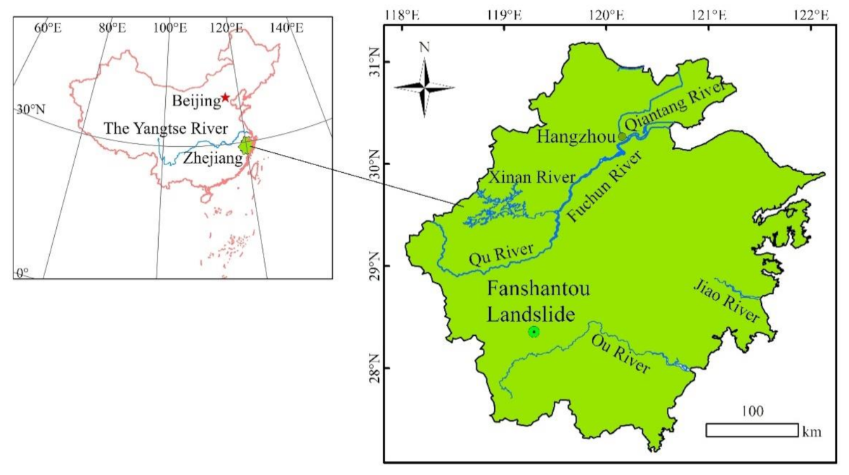
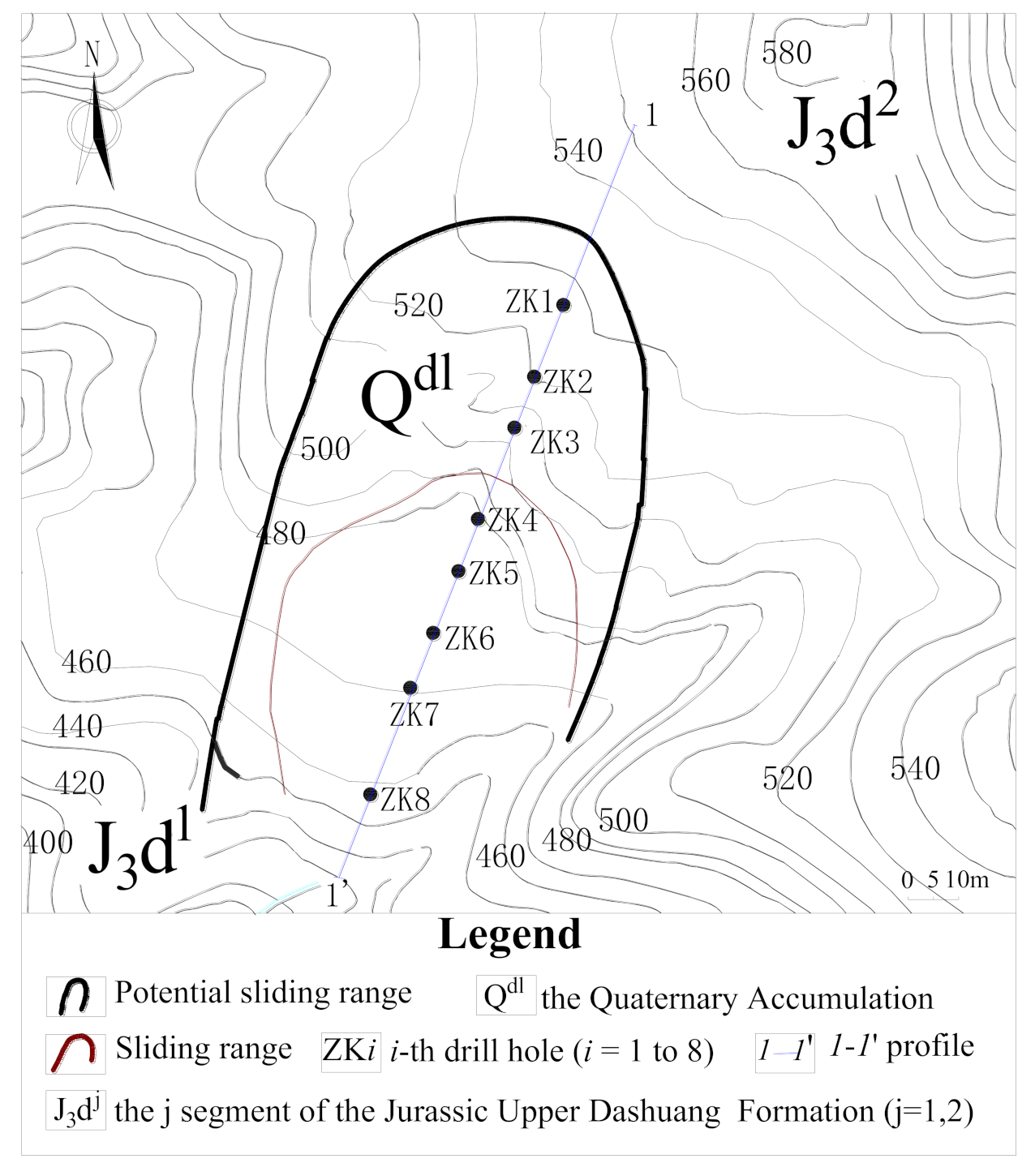
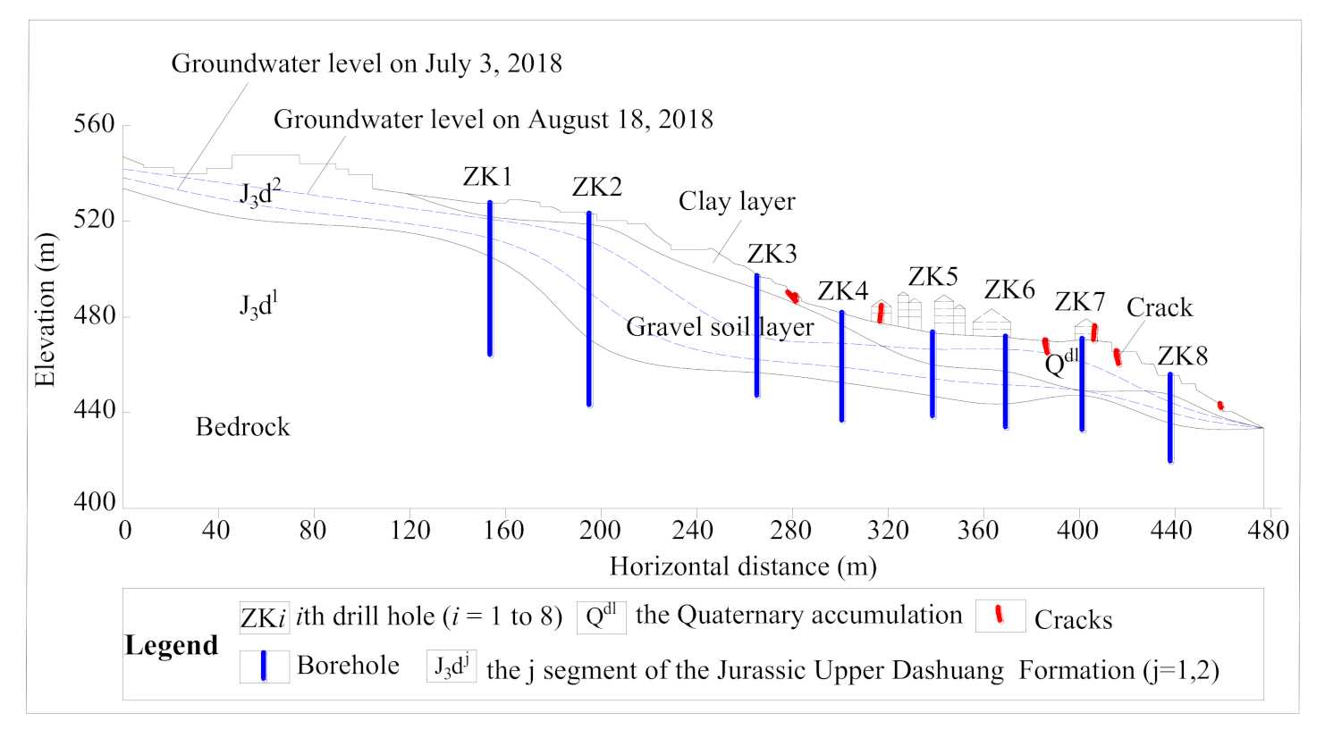
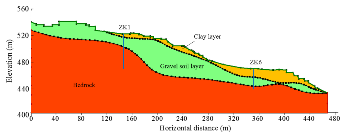
The Fanshantou landslide is located in Fanshantou village, Songyang County, Zhejiang Province (Figure 1); its geographic coordinates are 119°17′36″ east longitude and 28°21′20″ north latitude. The planar-view of the slope is shown in Figure 2. The potential landslide area is a steep mountain with a large area. The volume is about 2.85 million m3. The landslide area is located on a gentle slope on front of the mountain, with a volume of approximately 150,000 m3. Figure 3 shows the profile of the 1-1′ section in Figure 2. The landslide area is 200 m long, 200 m wide. The dip direction of the slope is 220°. The elevation of the foot of the slope is 420 m. The maximum elevation of the slope is 540 m. The height difference is 120 m. The upper slope dip is 25–35°, the middle slope dip is 5–15° (landslide section), and the lower slope dip is 25–35°.
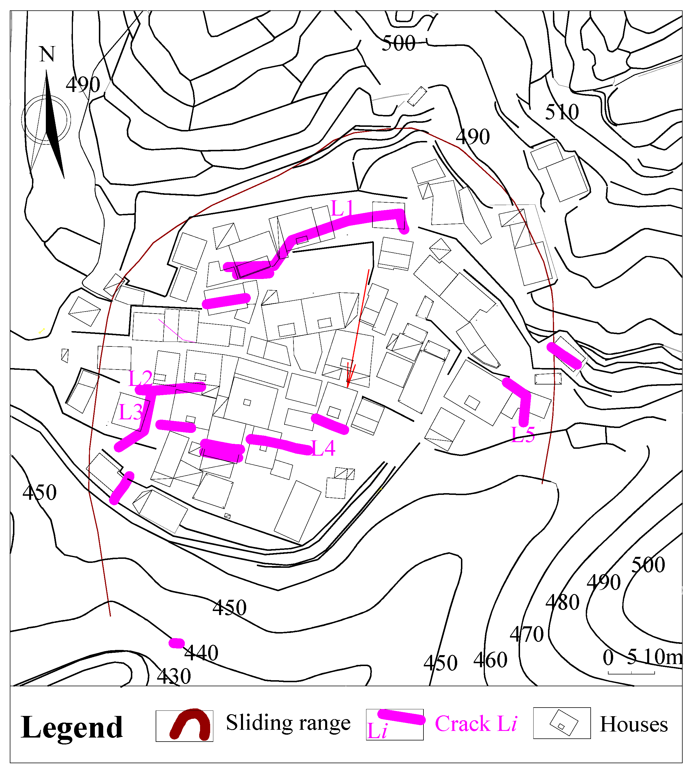
Figure 4 shows the planar view and crack distribution map of Fanshantou Village, which is the landslide area in Figure 2. On 27 July 2010, cracks appeared in the floors of 13 houses in Fanshantou village. The elevation is mainly 460–480 m above sea level. In the middle of the village, an almost fully connected arc-shaped crack, L1, formed from west to east. The cracks were mainly located near the toe of the landslide. As time passed, the cracks gradually increased and widened, forming a group of cracks, as shown in Figure 4.
The landslide area is characterized by a subtropical monsoon climate. The precipitation is mainly concentrated in the rainy season, from March to September. In the rainy season, the average cumulative rainfall is very high, accounting for three quarters of the total annual rainfall.
2.2. Lithology of the Landslide Strata
The geological map is shown in Figure 5. As a result of a combination of drilling, geophysical prospecting, in situ testing, and various types of experimental data, the lithology of the strata can be summarized as follows: the regional strata exposed mainly include the Lower Proterozoic Siyuan Formation (Pt1s) (distributed on the west side of the landslide area), the Jurassic Upper Dashuang Formation (J3d) (distributed on the west and northeast of landslide hazard area), and the Quaternary accumulation (Q) (distributed on the lower part of the slope).
Boreholes reveal that the deposits in the landslide area can be divided into two engineering geological layers: the clay layer and the gravel soil layer. Their distributions are given in Figure 3. The main composition contents of the two types of strata are shown in Table 1. The clay layer is distributed on the surface of the landslide. The gravel soil layer is distributed throughout the landslide area and is located below the clay layer (Figure 3). The clay layer is exposed at the surface at the back of the landslide. This layer is thicker in the middle and rear part of the landslide but thinner in the front part of the landslide. The bedrock in the lower part of the landslide area is an impermeable layer.
2.3. Hydrogeological Conditions
Pumping tests were carried out in different boreholes with different water table levels. The holes were drilled along the whole pipe. In addition, if there was more than one rock mass in a borehole, the filling method was used to separate the rock mass to obtain the permeability of a single rock mass. The test was carried out many times, and finally, the average value was taken according to the different measurement positions. The average permeability coefficient of the surface clay layer was 2.61 × 10⁻⁸ m/s, and the average permeability coefficient of the lower gravel soil layer was 2.85 × 10⁻⁶ m/s. The Fanshantou landslide has a binary hydrogeological structure, i.e., the clay layer with a lower permeability covers the gravel soil layer with a higher permeability. It should be noted that there is no clay layer with low permeability at the back of the landslide. Gravel soil layers with a high permeability are exposed on the surface (Figure 3). This stratum distribution provides good conditions for rainfall infiltration.
To the back of the slope, the highly permeable gravel soil layer is directly exposed at the surface. On the front of the slope, there is a poorly permeable clay layer. Therefore, the rear of the slope is more conducive to rainfall infiltration. This means that the groundwater table level at the rear will be the first to change with the rainfall. The representative high (18 August 2018) and low (3 July 2018) groundwater table levels are also plotted in Figure 3. It should be noted that (a) the cumulative rainfall within the 10 days before 18 August 2018 was 210 mm, and hence, the water table level on 18 August 2018 was selected as representative high groundwater table level; (b) the total rainfall within the 10 days before 3 July 2018 was 10 mm, and hence, that groundwater table level was selected to represent the low groundwater table level. The two groundwater lines in Figure 3 show that (a) on 18 August 2018, the groundwater table level in the front edge of the slope was higher than the bottom of the relatively impervious layer (clay layer), i.e., confined water formed; (b) on 3 July 2018, the groundwater table level was always lower than the bottom of the relatively impervious layer, which means that there was no confined water.
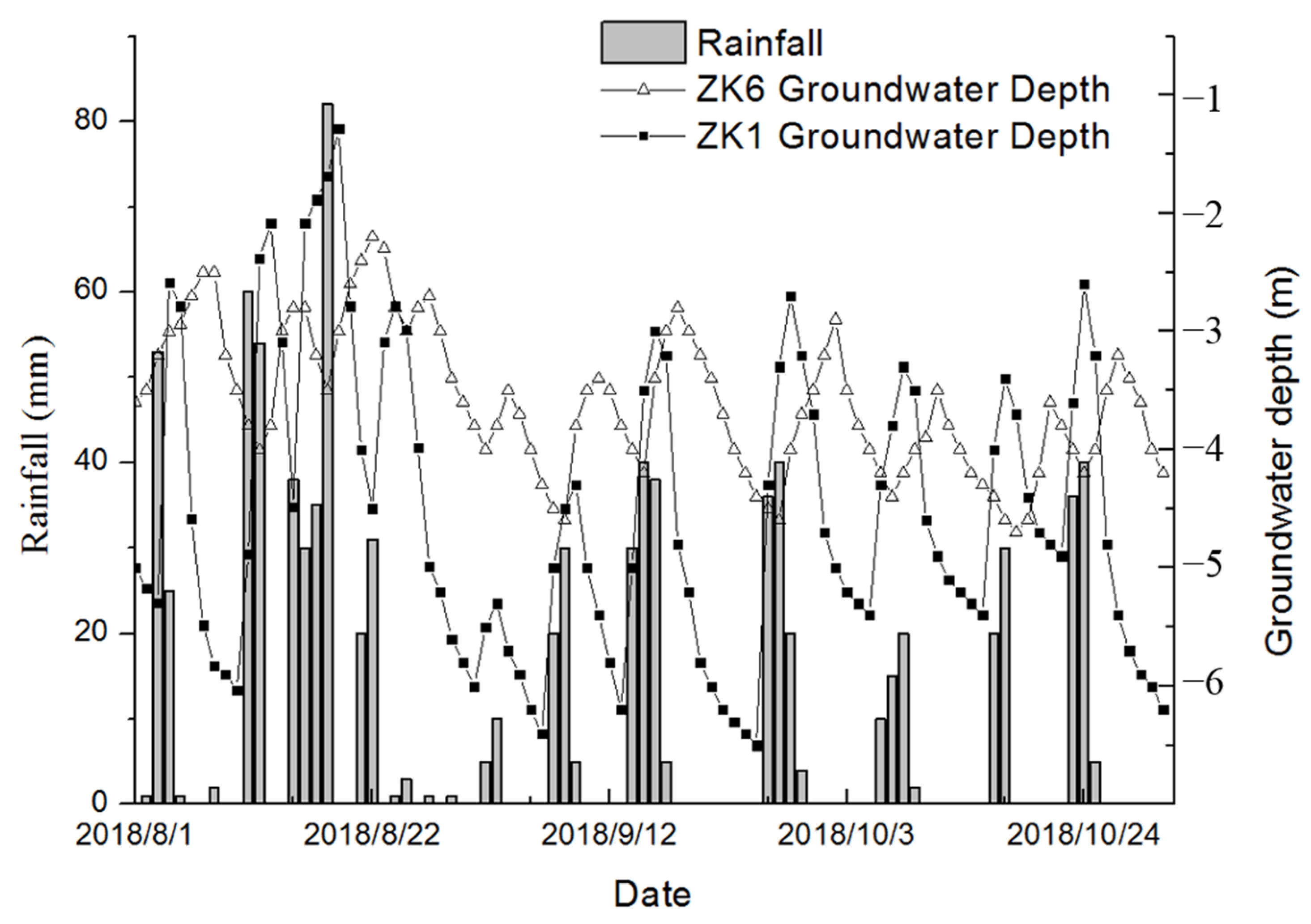
The variation in the groundwater table level in the slope during several rainfall events in August to October 2018 is shown in Figure 6. Choosing three months of data here to make the rules more convincing. Although the depth of the groundwater table varied at different times, the groundwater table level was closely related to the rainfall. Comparing the groundwater table levels of ZK1 in the rear margin and ZK6 in the front margin, it can be seen that the response times of the groundwater table level changes in different parts of the landslide were different. The groundwater table level of ZK1 reached its highest level within 2 days after rainfall and then quickly fell. However, the groundwater table level of ZK6 reached its highest level within 4 days after rainfall and then fell slowly.
3. Simulation of the Formation Process of Temporary Confined Water
Analyses of the deformation and failure development of the Fanshantou landslide revealed that the temporary confined water generated by rainfall infiltration was the main factor that induced the landslide. Numerical simulation studies on the formation process of temporary confined water, which is generated by rainfall infiltration, will help us to gain a better understanding of the genesis mechanism of the Fanshantou landslide. First, a numerical simulation of seepage based on the measured daily rainfall data from 2018 was conducted, and a comparison between the calculated and measured values of groundwater was used to validate the numerical simulation method. Then, the same modeling method was used to investigate the conditions under which temporary confined water formed by rainfall infiltration.
3.1. Numerical Model and Its Validation Analysis
Profile 1-1′ in Figure 3 was selected as the study section, and a corresponding A numerical model of slope seepage was constructed, as shown in Figure 7. The length and height of the model are 470 and 140 m, respectively. In the model, ZK1 and ZK6 are groundwater table level monitoring holes. The numerical simulation process was simulated using Seep/w in GEO-STUDIO 2012 software to study the characteristics of the slope seepage field.
The input hydraulic parameters are given in Table 2, which include the permeability coefficient, saturated volumetric water content, and the residual volumetric water content. Using the van Genuchten formula to fit the moisture characteristic curve, the residual volumetric water content was assumed to be one tenth of the saturated volumetric water content [20]. In addition, the model imposed zero flow at the contact between the second layer (gravel soil layer) and the bedrock. It should be noted that the bedrock was regarded as a water-tight layer because the bedrock’s permeability is very low, i.e., set to 0 in simulation.
As input parameters for the simulation, the measured water table level on 31 July 2008 was set as the initial water table level; the saturated volumetric water content and residual volumetric water content were assigned to the same stratum under and above the groundwater table level, respectively. No matter whether there was rainfall or not, the slope surface was the normal passage of water. Under the condition of no rainfall, there was no external infiltration on the slope surface. The idea of simulation was to define the fixed water head at the front and back edge of the landslide area, respectively, and set different periods of rainfall on the surface of the slope (Figure 8). Rainfall was added to the slope surface in the form of daily rainfall. Rainfall data were actually measured on site. The bedrock boundary of the entire model was impervious, and only the overlying clay layer and gravel soil layer were permeable. As a result of the poor permeability of the clay layer, the external replenishment of the slope can only be considered as the infiltration of gravel soil at the rear of the slope, as shown in Figure 8. Furthermore, it should be noted that the GEO-STUDIO software simulates the water quantity in the infiltration slope and the surface runoff according to the permeability of the surface rock and soil. Furthermore, the software ignored the impact of the surface runoff and simulated the change in groundwater table level in the slope body for different rainfall intensities and different initial water table levels.
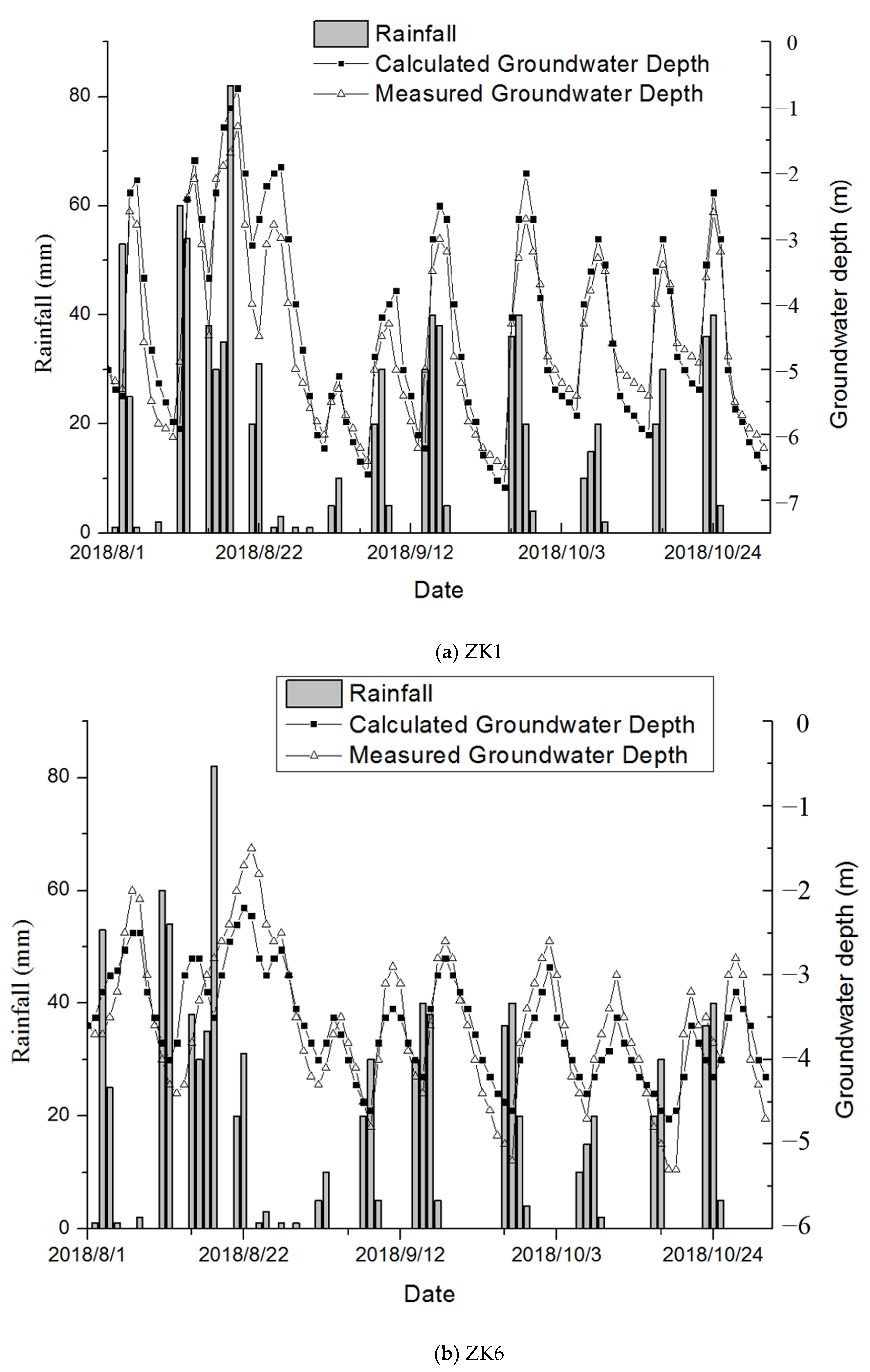
The measured daily rainfall data from 1 August to 31 October 2018 (Figure 6) were selected to validate the model. The rationality of the model was verified by comparing the calculated groundwater depth with the measured groundwater depth. The measured water table level on 31 July 2018 was taken as the simulated initial water table level and also as the boundary fixed head of the model. The rainfall condition was set as a function of water unit flow and time, and the daily actual rainfall data was input. The depths of water table levels in boreholes ZK1 and ZK6 were simulated for 3 months, and the simulated results were compared with the measured water table level from 1 August to 31 October 2018. The comparison results are given in Figure 9. The results in Figure 9 reflect the following findings. (a) With respect to ZK1, the calculated values are very close to the measured values at different moments; the majority of differences are less than 1 m, and the mean difference is 0.5 m. (b) With respect to ZK6, the calculated values are also very close to the measured values at different times; the majority of differences are less than 1.2 m, and the mean difference is 0.8 m. (c) The established numerical calculation model and method can reflect the characteristics of groundwater seepage in the Fanshantou landslide and can be further used to simulate the groundwater seepage field of other landslides.
3.2. Influence of Rainfall Intensity in the Rise in Groundwater Table Level
Different rainfall intensities produce different groundwater seepage field change processes. To facilitate the analysis of the seepage field characteristics of the slopes, the following different rainfall intensities were selected: 0, 10, 20, and 30 mm/d; 5 days was chosen as the continuous rainfall duration. The seepage field variation law under different rainfall intensities was studied under the same initial groundwater table level conditions.
The final groundwater table levels and the initial groundwater table level are given in Figure 9 for 5 d of rainfall with different intensities (0, 10, 20, and 30 mm/d). The results of Figure 10 show the following: (a) Before rainfall, the groundwater table level in the slope remains below the bottom of the clay layer, i.e., before rainfall, there is no confined water in the slope, and the groundwater is phreatic water. (b) During rainfall, the groundwater table level rises gradually, but the rate of increase and the range of the groundwater table level are different under different rainfall intensity conditions. (c) Under the 10 mm/d rainfall intensity condition, the groundwater table level of the slope never reaches the bottom of the clay layer, and confined water never forms. Therefore, under the natural conditions of low and moderate rainfall, groundwater always occurs in the form of phreatic water, and no confined water forms. (d) Under the 20 mm/d rainfall intensity condition, the groundwater table levels are higher than those of a rainfall intensity of 10 mm/d; after 72 h of rainfall, the groundwater table level near ZK6 in the front of the slope rises above the bottom of the clay layer, which means that confined water forms locally; with the continuation of rainfall, the scope of the confined zone gradually expands. (e) Under the 30 mm/d rainfall intensity condition, the most obvious characteristics are that a larger area of confined water, a higher pressure head of confined water, and the seepage area of groundwater appear; a field investigation also found that after heavy rainfall, a large number of spring seepages appear in the corresponding area; after 24 h of rainfall, the groundwater table level at ZK6 in front of the slope rises above the bottom of the clay layer, which means local confined water is formed; after 72 h of rainfall, the groundwater table level reaches the surface. (f) With the increase in rainfall intensity, it is inevitable that confined water will develop and cause frontal seepage.
3.3. Influence of Initial Water Table Level Condition on the Rise in the Groundwater Table Level
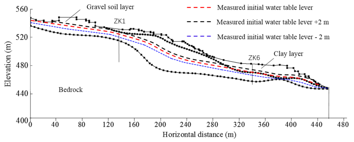
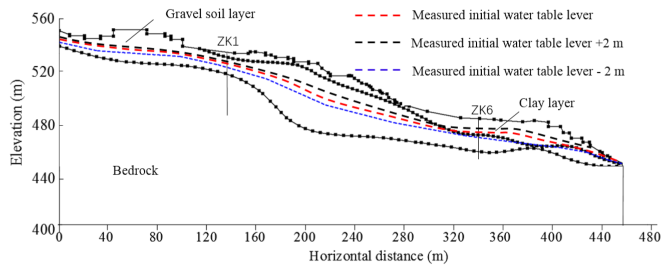
The initial groundwater table level condition reflects the accumulation of precipitation in the early stage. The influence of the initial groundwater table level conditions on the rise in the groundwater table level can be studied to reveal the extent of the influence of early rainfall accumulation on landslide stability. The initial groundwater level is the diving level. This is the normal water level inside the slope without rainfall. Under normal circumstances, the rise and fall of groundwater is not large, mostly within 2 m. For this reason, three models were analyzed. The measured initial water table level, the measured initial water table level +2 m, and the measured initial water table level −2 m were used as the initial water table levels of the three models (Figure 11). In addition, 20 mm/d was selected as the rainfall intensity, and 5 days were used for the duration of the rainfall in the three models.
The modeling results are given in Figure 12. With respect to the accumulation caused by the permeability binary structure, the influence of rainfall on slope stability is closely related to the initial groundwater table level of the slope. When the initial water table level is low, it takes a long time for the groundwater table level to rise, so confined water does not easily form. When the initial water table level is high, the superposition of rainfall infiltration quickly produces greater volumes of confined water. Generally, the higher the initial water table level, the greater the confined water pressure produced by the rainfall, and the greater the threat to slope stability.
3.4. Influence of Intermittent Rainfall
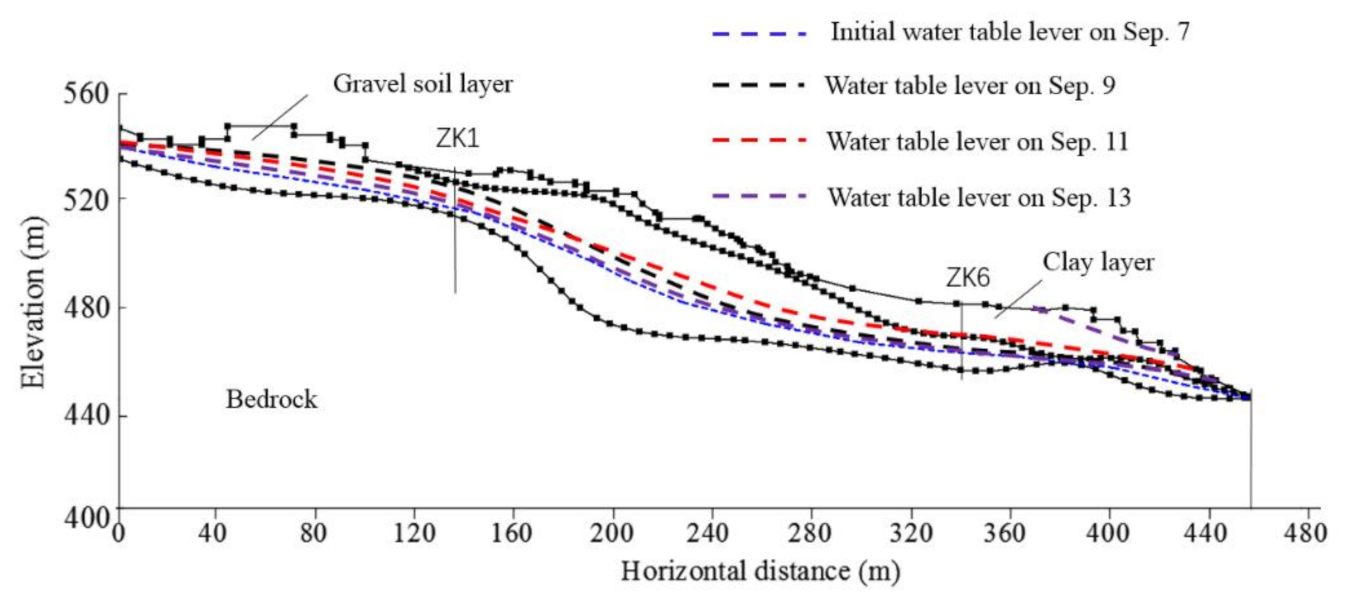
After discussing different rainfall intensities and different initial water levels, the intermittent rainfall situation was selected for a more realistic simulation. Choose the more distinctive real rainfall data from September 7th to September 13th to simulate the change of groundwater level.
Rainfall is shown in Table 3 below.
The modeling results are given in Figure 13. It can be seen from the figure that continuous rainfall occurred on September 7–8, and the water level at the rear edge of the slope rose rapidly. The water level in the rear reached its highest value on September 9, when the water level in the front hardly rose. With the transportation and flow of groundwater in the slope, the front water level reached its highest value on September 11, and temporary confined water appeared. At this time, the rear water level had fallen. When it reached September 13, the water levels at the front and rear had fallen, and the slope tended to be stable. This simulation shows that rainfall has a greater impact on the groundwater level of the slope, and the response time of the front and rear edges is different.
3.5. Analysis of Slope Factors of Safety under Different Conditions
In order to evaluate the stability of the landslide under the different simulation conditions discussed above, the limit equilibrium method was used. The module SLOPE/W in the GEO-STUDIO software was used, and the Morgenstern–Price method was selected. The groundwater table levels were directly imported, which are the simulated results above from Figure 9, Figure 10, Figure 11 and Figure 12. The input parameters for stability analysis are given in Table 4.
In the process of calculation, for the gravel soil layer with good permeability in the lower part, saturated and natural parameters were assigned to the same formation below and above the groundwater table, respectively. For the clay layer with poor permeability in the upper part, as a result of the action of confined water, natural parameters were selected for the stratum between the water-resistant roof and the water surface. The bottom surface of the gravel soil layer was selected for the sliding surface. It should be noted that the groundwater table levels under the different simulation conditions discussed above were obtained using the Seep/W module in GEO-STUDIO.
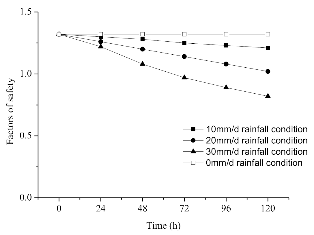
The factors of safety obtained under different rainfall conditions are plotted in Figure 14. Because the initial water table level conditions were the same, the initial factors of safety of the slope are the same. Figure 14 clearly shows that with the occurrence of rainfall, the slope’s factor of safety decreases to different degrees. When the rainfall intensity is 10 mm/d, the factor of safety decreases a little but is always larger than 1. When the rainfall intensity increases to 20 mm/d, the temporary confined water is formed gradually. The factor of safety gradually begins to drop below 1, and the slope becomes dangerous. When the rainfall intensity increases to 30 mm/d, the confined water begins to form more quickly and the factor of safety continues to drop below 1. Here, the slope is a safety issue. Therefore, rainfall intensity has a great influence on the stability of this type of slope.
The factors of safety obtained under different initial groundwater table level conditions are plotted in Figure 15. It clearly shows that: (a) For different initial groundwater table levels, the factor of safety decreases with the increase in rainfall duration. (b) The higher the initial water table level, the lower the factor of safety, and the easier it is for the slope to lose stability. (c) The factor of safety can be kept in a relatively safe range when the groundwater remains in the form of diving water in the permeable layer. When the groundwater crosses the bottom of the upper clay layer and produces temporary confined water, the factor of safety drops further, and the stability is greatly reduced.
The factors of safety obtained under intermittent rainfall conditions are plotted in Figure 16. Simulate the factors of safety of the slope under different times and different rainfall conditions. As the rainfall progressed, the factor of safety began to decrease due to the rising water level at the rear of the slope. As time progressed, the front groundwater level began to rise, temporary confined water began to appear, and the rate of decrease in the factor of safety accelerated. When the rain stopped for a period of time, the water levels at the front and back dropped, and the factor of safety continued to increase, returning to a safe state. This also proves that temporary confined water only appears under rainfall conditions, threatening the safety of slopes.
4. Discussions
On the basis of a field survey and monitoring data, this study explores the phenomenon of temporary confined water produced by gentle slopes on front of mountains due to their special dual stratum structure. The permeability of the surface clay of gentle slopes on the front of mountains is higher than the lower gravel soil layer. Under rainfall conditions, a large amount of rainwater infiltrates the supply area at the rear edge of the slope, and a drainage channel is formed inside the gentle front slope. As a result of the narrow discharge area, the gentle slope becomes an area that holds temporary confined water. Confined water forms easily and can remain for a relatively long time. The temporary confined water produced by the dual structure inside the gentle slope of the mountain is considered to be the key factor in inducing landslides. This kind of temporary confined water only appears when the rainfall intensity is sufficient, thus causing instability. GEO-STUDIO software was used to simulate the changes in the groundwater table level under different rainfall intensities and different initial water table levels. The simulation results clearly show that temporary confined water may appear under a certain combination of rainfall intensity and initial water table level. On the basis of the simulated groundwater table level, the slope stability was analyzed. It is obvious that the emergence of temporarily confined water has seriously threatened the safety of the slope. This kind of temporary confined water produces a larger floating force at the junction of impervious layers, causing cracks in and deformation of the slope. This is the fundamental reason why landslide disasters occur on gentle slopes on the front of mountains.
The landslide body is made up of different soil bodies with large differences in permeability, with spatial variability. The permeability depends on the composition of the fine content. This study does not consider these variabilities and uses the mean values as input parameters (Table 2). This may be the source of errors in the simulation results. Incorporating spatial variabilities of strata into the seep simulation may be considered in future research. In addition, future research can select more parameters for more numerical simulations. Get more specific conclusions with more pictures.
5. Conclusions
- It is generally believed that a gentle slope on the front of a mountain is equivalent to a loading berm, which is beneficial to the stability of the slope. In the study area, a landslide occurred on the gentle slope on the front of a mountain. Through geological analyses, it was found that this gentle slope has a special geological structure, i.e., the surface layer is impermeable clay soil, and the lower layer is gravel soil, which is conducive to the accumulation and occurrence of groundwater. Under continuous heavy rainfall, it will form “temporary confined water”.
- When there is an enlarged rear recharge area on a gentle slope on the front of the mountain, continuous rainfall will cause a large amount of groundwater to flow into the interior of the slope from the rear edge, which greatly promotes the formation of temporary confined water.
- Under conditions of continuous heavy rainfall, a gentle slope on the front of a mountain will crack and deform due to the upward floating force of the “temporary confined water” inside the gentle slope, which will eventually lead to landslide disasters.
- The numerical simulation results show that the formation of temporary confined water not only depends on the stratum structure, but also on the rainfall intensity and the initial groundwater table level. In the case of low-intensity rainfall, confined water is not generally produced, leaving diving water. When the initial water table level is low, the formation of temporary confined water during rainfall is difficult; when the initial water table level is high, the superposition of rainfall infiltration will quickly form temporary confined water; this important mechanism of rainfall accumulation affects the stability of landslides.
- The formation of temporary confined water in a gentle slope caused by continuous rainfall is the main factor that induces the gentle slope to slide. Therefore, the prevention and drainage of this type of landslide should be emphasized to reduce the external infiltration of the rear edge of the slope. For example, a surface interception drainage ditch can be installed in the rainfall infiltration area at the rear edge of the slope to reduce infiltration. Thus, when the local water table level is too high, the water can be drained to reduce the water pressure and prevent rainwater from infiltrating to form temporary confined water.
Author Contributions
Conceptualization, L.W. and Y.S.; methodology, L.W. and Y.S.; software, L.W.; validation, Y.Z., J.Z., and L.W.; formal analysis, L.W. and Y.S.; investigation, L.W. and J.Z.; resources, Y.Z.; data curation, L.W.; writing—original draft preparation, L.W. and Y.S.; writing—review and editing, J.Z.; visualization, L.W.; supervision, L.W. and Y.S.; project administration, L.W. and Y.S.; funding acquisition, Y.S. All authors have read and agreed to the published version of the manuscript.
Funding
This research is financially supported by the National Natural Science Foundation of China (Grant No. 41772276 and 41972264), and Key R&D project of Zhejiang Province (Grant No. 2017C03006).
Institutional Review Board Statement
Not applicable
Informed Consent Statement
Informed consent was obtained from all subjects involved in the study.
Data Availability Statement
The data used to support the findings of this study are available from the corresponding author upon request.
Acknowledgments
Thanks for the preliminary data provided by the Southern Zhejiang Comprehensive Engineering Survey Institute, Zhejiang Province, China.
Conflicts of Interest
The authors declare no conflict of interest.
References
- Zhao, Y.; Xu, M.; Guo, J.; Zhang, Q.; Zhao, H.; Kang, X.; Xia, Q. Accumulation characteristics, mechanism, and identification of an ancient translational landslide in China. Landslides 2014, 12, 1119–1130. [Google Scholar] [CrossRef]
- Yin, Y.; Cheng, Y.; Liang, J.; Wang, W. Heavy-rainfall-induced catastrophic rockslide-debris flow at Sanxicun, Dujiangyan, after the Wenchuan Ms 8.0 earthquake. Landslides. 2015, 13, 9–23. [Google Scholar] [CrossRef]
- Lee, D.-H.; Chen, P.; Wu, J.; Chang, Y.; Chang, K. Investigating the Rainfall-Induced Groundwater Variation and Movement of Highway Slope. Disaster Adv. 2013, 6, 142–153. [Google Scholar]
- Lee, D.-H.; Lai, M.; Wu, J.; Chi, Y.; Ko, W.; Lee, B. Slope Management Criteria for Alishan Highway based on Database of Heavy Rainfall-induced Slope Failures. Eng. Geol. 2013, 162, 97–107. [Google Scholar] [CrossRef]
- Wu, J.; Lin, W.; Hu, H. Post-failure simulations of a large slope failure using 3DEC: The Hsien-du-shan slope. Eng. Geol. 2018, 242, 92–107. [Google Scholar] [CrossRef]
- Zhang, X.; Yan, C.; Guo, S.; Tan, J.; Xu, C.; Liu, Y.; Huang, L. Derivation of stability formula of gentle slope affected by temporary confined water. J. Eng. Geol. 2020, 47, 133–141. [Google Scholar]
- Zhang, Z.; Wang, S.; Wang, L. Principles of Engineering Geological Analysis; Geological Publishing House: Beijing, China, 2005; pp. 314–355. [Google Scholar]
- Sun, J.; Wang, L.; Long, P. An assessment method for regional susceptibility of landslides under coupling condition of earthquake and rainfall. Chin. J. Rock Mech. Eng. 2011, 30, 752–760. [Google Scholar]
- Zhao, Q.; Sun, H.; Wang, Z. Influence of confined water on translational landslide. Chin. J. Rock Mech. Eng. 2012, 31, 762–769. [Google Scholar]
- Jiao, J.J.; Wang, X.; Nandy, S. Confined groundwater zone and slope instability in weathered igneous rocks in Hong Kong. Eng. Geol. 2005, 80, 145–149. [Google Scholar] [CrossRef]
- Jiao, J.J.; Ding, G.; Leung, C.M. Confined groundwater near the rock head in igneous rocks in the Mid-Levels area, Hong Kong, China. Eng. Geol. 2006, 84, 207–219. [Google Scholar] [CrossRef]
- Borgatti, L.; Cervi, F.; Corsini, A. Hydro-mechanical mechanisms of landslide reactivation in heterogeneous rock masses of the northern Apennines (Italy). In Proceedings of the First North American Landslide Conference, Landslides and Society, Vail, CO, USA, 3–10 June 2007; pp. 749–758. [Google Scholar]
- Mikoš, M.; Četina, M.; Brilly, M. Hydrologic conditions responsible for triggering the Stoze landslide, Slovenia. Eng. Geol. 2004, 73, 193–213. [Google Scholar]
- Tu, Y. Study on the artesian water model of translational landslide. Chin. J. Rock Mech. Eng. 2018, 37, 2110–2119. [Google Scholar]
- Liu, G.E.; Dai, B.; Sui, Z.X. On landslide mechanism and prevention measures of Zhutoushan, Pukou district, Nanjing. Jiangsu Geol. 2007, 4, 319–322. [Google Scholar]
- Gao, Z.Z.; Yan, C.H.; Xu, B.T. Analysis of landslide mechanism based on automatic monitoring in Zhenjiang area. Geotech. Investig. Surv. 2018, 46, 17–22. [Google Scholar]
- Tan, J.Z.; Ni, X.P.; Wang, W.D. Landslide disaster treatment project and its synthetic utilization in Yanziji, Nanjin. J. Geol. Hazards Environ. Preserv. 2009, 20, 11–15. [Google Scholar]
- Yu, L.C.; Yan, C.H.; Guo, S.L. An analysis of sliding mechanism of Youzi Mountain affected by temporary confined water in a confined aquifer in Nanjing. Hydrogeol. Eng. Geol. 2020, 1, 1–8. [Google Scholar]
- Yan, C.H.; Xu, B.T.; Wu, C.Y. The stratigraphic structure and stability analysis in gentle slopes of piedmontat Ningzhen Area. J. Eng. Geol. 2019, 27, 48–54. [Google Scholar]
- Xiao, J.Y.; Li, Y.T.; Wang, L. Fitting Soil Water Characteristic Curve Based On the Van Genuchter Model. Underground 2007, 29, 46–47. [Google Scholar]
Figure 1.
Location of the Fanshantou landslide.

Figure 2.
Planar view of the Fanshantou landslide (made on 1 July 2018).

Figure 3.
Profile of section 1-1′ in Figure 2 of the Fanshantou landslide.
Figure 3.
Profile of section 1-1′ in Figure 2 of the Fanshantou landslide.

Figure 4.
Planar view and crack distribution map of the Fanshantou landslide.

Figure 5.
Geological map (made on 1 July 2018).

Figure 6.
Relationship between the groundwater depth in boreholes ZK1 and ZK6 in the slope and rainfall during the period between 1 August 2018 and 31 October 2018.
Figure 6.
Relationship between the groundwater depth in boreholes ZK1 and ZK6 in the slope and rainfall during the period between 1 August 2018 and 31 October 2018.

Figure 7.
Numerical simulation model.

Figure 8.
Model of rainfall applied to the whole slope.

Figure 9.
Calculated and measured values of groundwater depth during the period between 1 August 2018 and 31 October 2018.
Figure 9.
Calculated and measured values of groundwater depth during the period between 1 August 2018 and 31 October 2018.

Figure 10.
Results of the seepage field of the slope after 5 days of rainfall of different intensities.
Figure 10.
Results of the seepage field of the slope after 5 days of rainfall of different intensities.

Figure 11.
Three calculation conditions with different initial water table levels, which are equal to the measured initial water table level, the measured initial water table level +2 m, and the measured initial water table level −2.
Figure 11.
Three calculation conditions with different initial water table levels, which are equal to the measured initial water table level, the measured initial water table level +2 m, and the measured initial water table level −2.

Figure 12.
Seepage fields for different initial water table levels under the same rainfall conditions.
Figure 12.
Seepage fields for different initial water table levels under the same rainfall conditions.

Figure 13.
Seepage fields for intermittent rainfall.

Figure 14.
Factors of safety vs. time with respect to different rainfall conditions.

Figure 15.
Factors of safety vs. time with respect to different initial water table levels.

Figure 16.
Factor of safety vs. time with respect to intermittent rainfall conditions.


Table 1.
Composition contents of two types of strata.
| Soil Type | Breccia or Gravel Content | Clay Content |
|---|---|---|
| Clay layer | 5–20% | 80–95% |
| Gravel soil layer | 50–75% | 25–50% |
Table 2.
Model material parameters of different formations.
| Types of Rock and Soil | Saturated Permeability (m/s) | Residual Volumetric Water Content (m3/m3) | Saturated Volumetric Water Content (m3/m3) |
|---|---|---|---|
| Clay layer | 2.61 × 10⁻⁸ | 0.0038 | 0.38 |
| Gravel soil layer | 2.85 × 10⁻⁶ | 0.08 | 0.8 |
| Bedrock | 0 | 0 | 0 |
Table 3.
Rainfall for 7 days.
| Date | September 7 | September 8 | September 9 | September 10 | September 11 | September 12 | September 13 |
|---|---|---|---|---|---|---|---|
| Rainfall (mm) | 20 | 30 | 5 | 0 | 0 | 0 | 0 |
Table 4.
Physical and geometric parameters.
| Soil Name | ρ (kg/m3) | c (kPa) | φ (°) | |||
|---|---|---|---|---|---|---|
| Saturated | Natural | Saturated | Natural | Saturated | Natural | |
| Clay layer | 1900 | 1750 | 30 | 33 | 15 | 19.3 |
| Gravel soil layer | 2300 | 2180 | 0 | 5 | 35 | 38 |
Publisher’s Note: MDPI stays neutral with regard to jurisdictional claims in published maps and institutional affiliations. |
© 2021 by the authors. Licensee MDPI, Basel, Switzerland. This article is an open access article distributed under the terms and conditions of the Creative Commons Attribution (CC BY) license (http://creativecommons.org/licenses/by/4.0/).
Share and Cite
MDPI and ACS Style
Wang, L.; Shang, Y.; Zheng, J.; Zhang, Y. Temporary Confined Water-Induced Landslide in the Binary Structure of a Gentle Slope: A Case Study of the Fanshantou Landslide. Water 2021, 13, 596. https://doi.org/10.3390/w13050596
AMA Style
Wang L, Shang Y, Zheng J, Zhang Y. Temporary Confined Water-Induced Landslide in the Binary Structure of a Gentle Slope: A Case Study of the Fanshantou Landslide. Water. 2021; 13(5):596. https://doi.org/10.3390/w13050596
Chicago/Turabian StyleWang, Lei, Yuequan Shang, Jun Zheng, and Yingqiu Zhang. 2021. "Temporary Confined Water-Induced Landslide in the Binary Structure of a Gentle Slope: A Case Study of the Fanshantou Landslide" Water 13, no. 5: 596. https://doi.org/10.3390/w13050596
Note that from the first issue of 2016, this journal uses article numbers instead of page numbers. See further details here.